
Nearby Hiking
Colorado Springs Parks and Open Spaces
Sightseeing
Accessible directly out the back gate of the back yard, the Rockrimmon open space extends westward to the Village Center shops (Safeway groceries, several restaurants, library branch) and connects with a neighborhood greenway which will lead you northeast past a local elementary school and beyond.
To the south end of the open space is a steep hike up a knob that overlooks the neighborhood to the north and west, and offers views of downtown to the south and Palmer Park and the University of Colorado CS campus to the east.
For the intrepid, you can connect to Ute Valley Park hikes beyond the shops at Village Center by traveling behind Eagleview Middle school to the south of the shops and Vindicator boulevard.
This area was the site of coal mining several hundred feet underground approximately 100+ years ago. It's now a corridor for wildlife, and in some years coyote packs can be heard howling at night.
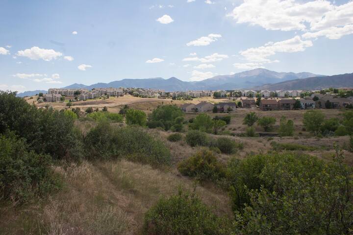
Rockrimmon Open Space
Perfect ViewAccessible directly out the back gate of the back yard, the Rockrimmon open space extends westward to the Village Center shops (Safeway groceries, several restaurants, library branch) and connects with a neighborhood greenway which will lead you northeast past a local elementary school and beyond.
To the south end of the open space is a steep hike up a knob that overlooks the neighborhood to the north and west, and offers views of downtown to the south and Palmer Park and the University of Colorado CS campus to the east.
For the intrepid, you can connect to Ute Valley Park hikes beyond the shops at Village Center by traveling behind Eagleview Middle school to the south of the shops and Vindicator boulevard.
This area was the site of coal mining several hundred feet underground approximately 100+ years ago. It's now a corridor for wildlife, and in some years coyote packs can be heard howling at night.
Ute Valley Park offers unique topology and geology for the area. The rock color changes to a notable pale sandstone in this park, and it's fairly arid.
The topology ranges from shady shallow canyon areas to climbable ridgetops with views.
This park is popular for both mountain biking and hiking, with some trails reserved for hikers only. The ridge at the western border of the park offers views back over Colorado Springs, and a peek at the neighborhood to the west if you're on top.
Dogs may enjoy the narrow creek that runs when there's enough recent rainfall.
Park Map: https://coloradosprings.gov/sites/default/files/inline-images/utevalleypark_trailmap_011320208.pdf
58 現地メンバーのおすすめ
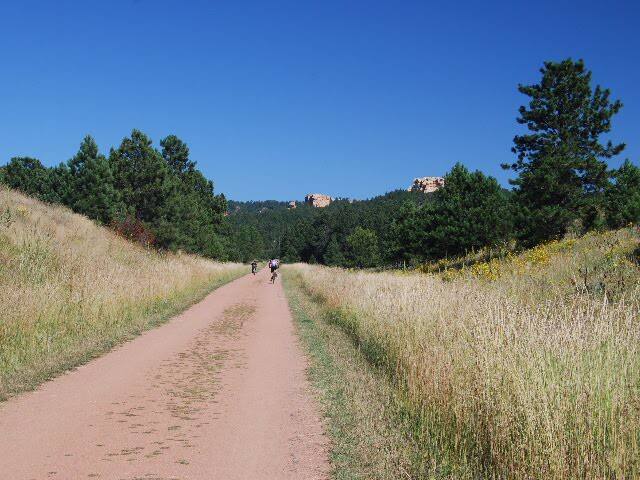
Ute Valley Park
1705 Vindicator DrUte Valley Park offers unique topology and geology for the area. The rock color changes to a notable pale sandstone in this park, and it's fairly arid.
The topology ranges from shady shallow canyon areas to climbable ridgetops with views.
This park is popular for both mountain biking and hiking, with some trails reserved for hikers only. The ridge at the western border of the park offers views back over Colorado Springs, and a peek at the neighborhood to the west if you're on top.
Dogs may enjoy the narrow creek that runs when there's enough recent rainfall.
Park Map: https://coloradosprings.gov/sites/default/files/inline-images/utevalleypark_trailmap_011320208.pdf
The New Santa Fe Regional Trail is a maintained portion of the legendary Santa Fe trail that carried US citizens westward on their quest for land, mining riches, and a new start.
Labeled as the Pikes Peak Greenway trail in Coloarado Springs, it's accessible within minutes of the house by bike or foot, and extends through the Air Force Academy to the North, and through downtown Colorado Springs and beyond to the south. Due to the distances involved, a bike is the preferred mode of travel.
To find this trail departing from the house, go north on Saddlemountain to a trail that connects to a greenway path, but also emerges near a stoplight on Delmonico Boulevard. Cross Delmonico and enter Golden Hills Park. A trail behind the play area at the southeast corner of the park leads to the Santa Fe Regional trail. Turn right (S) to head for downtown, passing a large pond, soccer fields, a BMX park, and Colorado College. Turn left (N) to pass into the Air Force Academy grounds and eventually past their light plane and glider training field, then into the towns of Palmer Lake and Monument to the far north.
There's also a small parking lot on Woodmen Rd between Delmonico and Corporate Center Drive that provides easy access to the trail.
Urban Trail Map: https://coloradosprings.gov/sites/default/files/parks_recreation_and_cultural_services/trails/urban_trail_map.pdf
New Santa Fe Regional Trail
New Santa Fe Regional TrailThe New Santa Fe Regional Trail is a maintained portion of the legendary Santa Fe trail that carried US citizens westward on their quest for land, mining riches, and a new start.
Labeled as the Pikes Peak Greenway trail in Coloarado Springs, it's accessible within minutes of the house by bike or foot, and extends through the Air Force Academy to the North, and through downtown Colorado Springs and beyond to the south. Due to the distances involved, a bike is the preferred mode of travel.
To find this trail departing from the house, go north on Saddlemountain to a trail that connects to a greenway path, but also emerges near a stoplight on Delmonico Boulevard. Cross Delmonico and enter Golden Hills Park. A trail behind the play area at the southeast corner of the park leads to the Santa Fe Regional trail. Turn right (S) to head for downtown, passing a large pond, soccer fields, a BMX park, and Colorado College. Turn left (N) to pass into the Air Force Academy grounds and eventually past their light plane and glider training field, then into the towns of Palmer Lake and Monument to the far north.
There's also a small parking lot on Woodmen Rd between Delmonico and Corporate Center Drive that provides easy access to the trail.
Urban Trail Map: https://coloradosprings.gov/sites/default/files/parks_recreation_and_cultural_services/trails/urban_trail_map.pdf
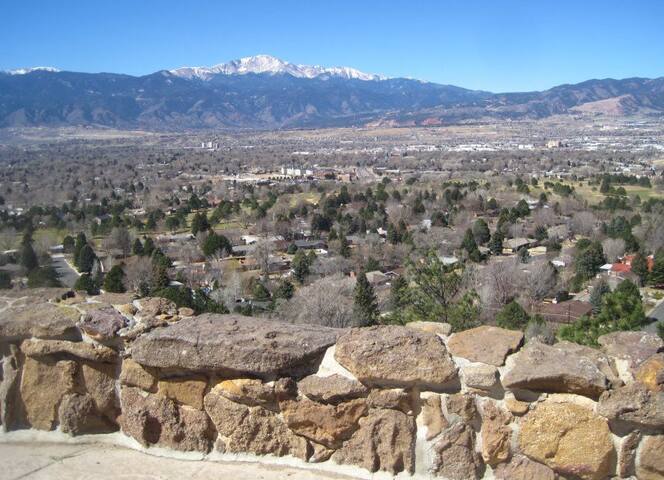
Palmer Park is one of the large city parks that was set aside b the founders, named after city founder General William Jackson Palmer.
It hosts many activities, from an off-leash dog walking area on a top ridge of a park to horse stables and equestrian activities based at an entrance on the northwest side.
The unique narrow road passing through the park and connecting the entrances is an experience in itself as it rises from the neighborhood nearby to a summit point, then down to the gate on the other side.
Hiking, technical mountain biking, horse riding, and dog walking, and picnicking are all popular in the park.
Park Info: https://coloradosprings.gov/parks/page/palmer-park
176 現地メンバーのおすすめ
パーマー公園
3344-3376 Paseo RdPalmer Park is one of the large city parks that was set aside b the founders, named after city founder General William Jackson Palmer.
It hosts many activities, from an off-leash dog walking area on a top ridge of a park to horse stables and equestrian activities based at an entrance on the northwest side.
The unique narrow road passing through the park and connecting the entrances is an experience in itself as it rises from the neighborhood nearby to a summit point, then down to the gate on the other side.
Hiking, technical mountain biking, horse riding, and dog walking, and picnicking are all popular in the park.
Park Info: https://coloradosprings.gov/parks/page/palmer-park
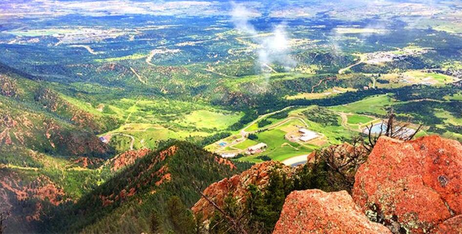
Blodgett Peak offers a scenic hike that is minutes away by car from the house. For the intrepid, a hike of a couple hours climbing will yield a fantastic view of the city and the Air Force Academy.
To get to the Blodgett Peak parking area, drive west from the house to Vindicator Drive at the junction of Rockrimmon N/S and Vindicator. Take Vindicator west past Ute Valley Park to the stoplight at Centennial Drive. Turn right on Centennial, and climb with the road until you're nearly at a high point. The parking area will be on your left.
Bring water and snacks if you're planning to get to the top of the peak.
More information:
https://coloradosprings.gov/parks/page/blodgett-peak-open-space
21 現地メンバーのおすすめ
ブロジェット・ピーク・オープン・スペース
3786 W Woodmen RdBlodgett Peak offers a scenic hike that is minutes away by car from the house. For the intrepid, a hike of a couple hours climbing will yield a fantastic view of the city and the Air Force Academy.
To get to the Blodgett Peak parking area, drive west from the house to Vindicator Drive at the junction of Rockrimmon N/S and Vindicator. Take Vindicator west past Ute Valley Park to the stoplight at Centennial Drive. Turn right on Centennial, and climb with the road until you're nearly at a high point. The parking area will be on your left.
Bring water and snacks if you're planning to get to the top of the peak.
More information:
https://coloradosprings.gov/parks/page/blodgett-peak-open-space
旅行者へのアドバイス
交通アクセス
Link to Favorite City Parks and Open Spaces:
Use this link to look into more Colorado Springs parks and open spaces:
https://coloradosprings.gov/parktrails?mlid=35056